Explorer of the Seas
Introduction
Institutions
Data
Observations
About the Model
Data Assimilation
Assimilation Products
Assimilation Impact
Ensemble Archives
References
Acknowledgements
The Caribbean Sea Circulation
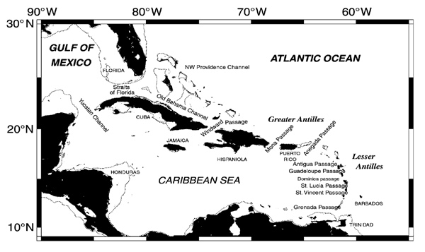
While we will consider the entire IAS, our primary focus will be the Caribbean Sea which has received less attention than the Gulf of Mexico. The Caribbean Sea is characterized by a number of deep basins, complex bathymetry and geometry. To the south and west it is bounded by South and Central America, to the north by Cuba, Hispaniola, Puerto Rico and the Virgin Islands (the Greater Antilles), and to the east by the island chain of the Lesser Antilles. The geography of the region is shown in the Figure below from Wilson and Johns (1997). The Caribbean Sea is composed of numerous water masses of different origin that enter through the various island passages (Wust, 1964; Metcalf, 1976; Morrison and Nowlin, 1982). Some of these waters originate in the North Atlantic (e.g. NADW), while others flow from the South Atlantic with origins further afield (e.g. the Southern, Pacific and Indian Oceans). The circulation is also influenced by freshwater inflow from the Mississippi, Amazon, Orinoco and Magdalena Rivers (e.g. Morell and Corredor, 2001; Morey et al., 2003a; Morey et al., 2003b; Corredor et al., 2004).
The Caribbean circulation is under the constant influence of the tropical Atlantic Trade Winds, which are typically strongest during boreal Summer. Transient atmospheric forcing in the form of easterly waves and hurricanes also plays a significant, yet not well understood, role in shaping the ocean circulation. Some of the first descriptions of the Caribbean Sea circulation are those of Wust (1964), Gordon (1967) and Worthington (1976), while a more recent and comprehensive review is that of Mooers and Maul (1998).
While it is difficult to define a mean circulation for the Caribbean due to its highly variable nature (Centurioni and Niiler, 2003), the surface circulation appears to be dominated by the Caribbean Current fed by ocean transport through various island passages. In the central Caribbean, the Caribbean Current appears to take the form of two jets centered near 13°N and 15°N, separated by a relatively weak eastward flow (Morrison and Nowlin, 1982). Recent observations (Wilson and Johns, 1997; Johns et al., 1999, 2002) indicate that the Caribbean inflow is partitioned nearly equally between the Windward Island passages (~ 10 Sv) (Grenada, St. Vincent, St. Lucia), Leeward Island passages (~ 8 Sv) (Dominica, Guadeloupe, Antigua, Anegada) and Greater Antilles passages (~ 10 Sv) (Mona, Windward). A dome of ocean dynamic height exists south of Hispaniola where the two currents merge and flow northwestwards as the Yucatan Current. This is also the region of largest sea surface height variability observed by satellite altimeters (Andrade and Barton, 2000; Bosch et al., 2002; Oey et al., 2003) which may be linked to the bathymetry, though the role of the local wind stress curl is less clear. On entering the Gulf of Mexico the Yucatan Current becomes the Loop Current, which exits the Gulf south of Florida to become the Florida Current. An interesting transient feature associated with the Yucatan and Loop currents is the Tortugas Gyre that aperiodically forms and dissipates to the southwest of Florida. Other surface currents of note are the Panama-Colombia Gyre in the SW Caribbean, the coastal branch of which is sometimes referred to as the Panama-Colombia Countercurrent.
East of the Antilles island chain the surface circulation is characterized by the northward Antilles Current, apparently wind driven, perhaps forming part of the western boundary current that closes the North Atlantic Sverdrup circulation (Lee et al., 1996).
Much less is known about the deep circulation of the region. To the east of the Antilles, a Deep Western Boundary Current (DWBC) forms part of the North Atlantic thermohaline circulation. From timeseries of DWBC observations at 26.5°N just east of Abaco, Bahamas, Lee et al. (1996) found that the mean DWBC transport was ~ 40 Sv, some 2-3 times larger than the accepted value, indicating that a significant fraction of DWBC flow must recirculate in the North Atlantic. Model studies suggest that this occurs primarily along f/h contours associated with local bathymetric features. Lee et al. (1996) also found significant variations in DWBC transport as large as 60 Sv associated with offshore excursions and meanders of the current. The local transport variability in this region is well correlated with the strength of the Bermuda High. The deep flows in this region are also dominated by eddies, perhaps a result of baroclinic instability, as evidenced by float data (Leaman and Vertes, 1996). The deepest island passages are Anegada (1900 m) and Windward Passage (1700 m), and ventilation of the Venezuelan, Colombian, Cayman and Yucatan basins occurs via these passages (~ 0.2 Sv). In the central Caribbean Sea, the deep flow is apparently dominated by a cyclonic circulation as inferred from inverse calculations (Roemmich, 1981; Joyce et al., 2001), and is perhaps to be expected based on dynamical arguments (Sou et al., 1996). There is also observational evidence for deep eastward flow along the entire southern boundary of the Caribbean Sea (Andrade et al., 2003), and numerous estimates of ventilation, deep flow pathways and transports have appeared in the literature (e.g. Morrison and Nowlin, 1982; Joyce et al., 2001).
A major physical oceanographic issue in the Caribbean Sea has always been the validity of the Sverdrup theory. Leetmaa et al. (1977) showed that the northward transport by the Florida Current at 25°N agrees well with the southward Sverdrup transport of the interior portion of the subtropical gyre. However, it has since been established that the thermohaline circulation in the Atlantic transports approximately 15 Sv of cold water southward across the equator, which is balanced at the surface by the northward transport of relatively warm thermocline and intermediate waters (Schmitz and McCartney, 1993). The pathways of this S Atlantic water, however, are not well known. Recent estimates (Schmitz and Richardson, 1991; Lee et al., 1996) suggest that as much as 13 of the 31.5 Sv carried by the Florida Current from the Caribbean may be associated with the thermohaline circulation, an estimate confirmed by some models (Johns et al., 2002).
Whether Sverdrup theory holds in the Caribbean Sea is an interesting issue and continues to attract attention. Mayer and Weisberg (1993) showed that the Sverdrup transport entering the southern passages of the Lesser Antilles would have to exit the Caribbean Sea southwards as a western boundary current along the coast of South America so as to close the tropical gyre. Observations by Andrade et al. (2003) suggest that elements of this idea may be true. Using the island circulation rule, Wajsowicz (2002) argued that Sverdrup dynamics may be valid if the thermohaline circulation is confined to the western boundary current. Mass conservation requires that the observed Florida Current transport (31.5±1.5 Sv) is fed by inflow through the island passages. There are nine island passages along the Antilles arc between Cuba and South America with sill depths > 400 m through which significant transport can occur (above Figure). Despite numerous estimates of island passage transports in the literature (Model, 1950; Gordon, 1967; Stalcup and Metcalf, 1972; Worthington, 1976; Metcalf, 1976; Brooks, 1978; Roemmich, 1981, 1983; Schmitz and Richardson, 1991) they were, until recently poorly observed. Recent repeat observations from the Windward Island Passages Program (WIPP; Wilson and Johns, 1997) are summarized in the Figure below adapted from Fig. 14 of Johns et al. (2002). The vertical structure of the transport is also quite complicated consisting, in some passages, of topographically steered undercurrents and countercurrents (Wilson and Johns, 1997). The passage transports are highly variable, and the standard deviation is often as large as the mean, and apparently associated with eddy variability, the seasonal cycle being weak (W. Johns, pers. comm.). Some of the islands themselves are known to shed eddies, and eddies also propagate into the region from the NE Brazil Current Retroflection; perhaps transmitted through the island passages via mechanisms similar to those described by Pedlosky and Spall (1999).
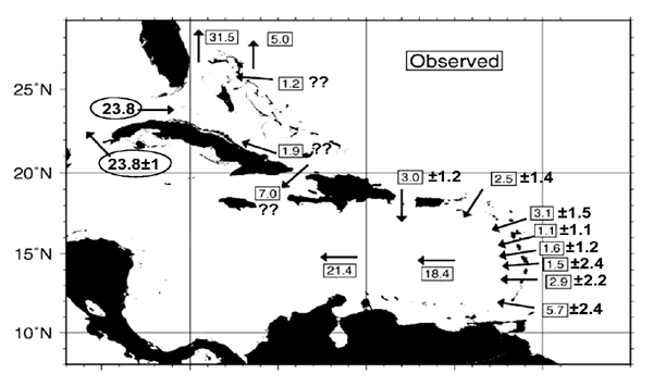
Until recently, it was assumed that of the 31.5 Sv carried by the Florida Current, 28.4 Sv passed through the Yucatan Channel supplemented by 1.9 Sv through Old Bahama Channel and 1.2 Sv through the NW Providence Channel (see above Figures). Recent direct measurements made over several years, however, indicate that the mean transport through the Yucatan Channel is ~ 23.8 ± 1 Sv (Sheinbaum et al., 2002; Abascal et al., 2003) which is circled in the above Figure. Considerable uncertainty, exists in the Windward Passage transport; Johns et al. (2002) suggest that it could be anywhere in the range of 3-9 Sv. In light of the Sheinbaum et al. (2002) measurements, questionable transports are indicated above by "??". One objective of the proposed research is to ascertain the most likely transport magnitudes and pathways within the IAS based on available ocean data.
We note also that the IAS has also been the subject of numerous numerical modeling studies (e.g. Hurlburt and Thompson, 1980; Fratantoni et al., 1995; Murphy et al., 1999; Johns et al., 2002; Kuznetsov et al., 2002; Toner et al., 2003; Zavala-Hidalgo et al., 2003; Ezer et al, 2003; Wang et al., 2003; Sheng and Tang, 2003; Oey et al., 2003; Romanou et al., 2004).